Arcadis
Arcadis helps Hong Kong ensure security of service for extreme weather events using InfoWorks ICM
Storm, Sewer, Flood
Share this story
Summary
Arcadis, a global design, engineering, and management consulting firm known for their expertise in stormwater and wastewater management, was commissioned to support their client’s long-term resilience investment strategy by using catchment-level hydraulic modeling and holistic risk assessment to assess the flood risks that can arise from extreme weather events. The complexity and regional scale of the project required them to explore new techniques for developing a modeling strategy that enabled them to assess rainfall, storm surges, and sea wave overtopping - all concurrently.
The challenge of modeling a dynamic, expanding infrastructure
Planning for extreme weather gets a lot harder in cities. One of the key challenges of this Arcadis-led project was modeling the unique urban landscape of Hong Kong. The city contains extensive footbridges, elevated roads, and steep slopes, all of which create spatial forms that can’t be easily captured from topographic plans or by using satellite imagery. Moreover, the city’s development plans are incredibly dynamic, with multiple construction works running concurrently. The digital terrain models they worked with captured deep excavations of proposed or in-progress construction sites. If not addressed, these voids in the model could lead to unrealistic flooding predictions.
To overcome these challenges, the modelling team needed to get creative and adopt digital data from multiple sources and validate their work with field visits when required. The team was able to replicate complex urban features like road kerbs and building thresholds at the city scale to ensure confidence in the predictions by relying heavily on InfoWorks ICM’s mesh zones and mesh-level zones, which seamless integrate with most GIS formats.
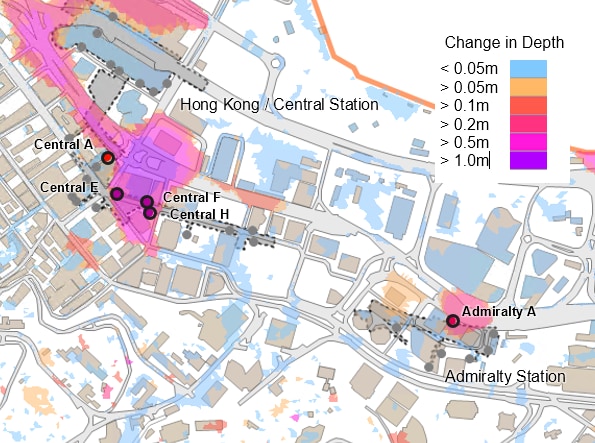
Future change in 200-year floodwater depth.
Illustrating advice to stakeholders using thematic mapping styles
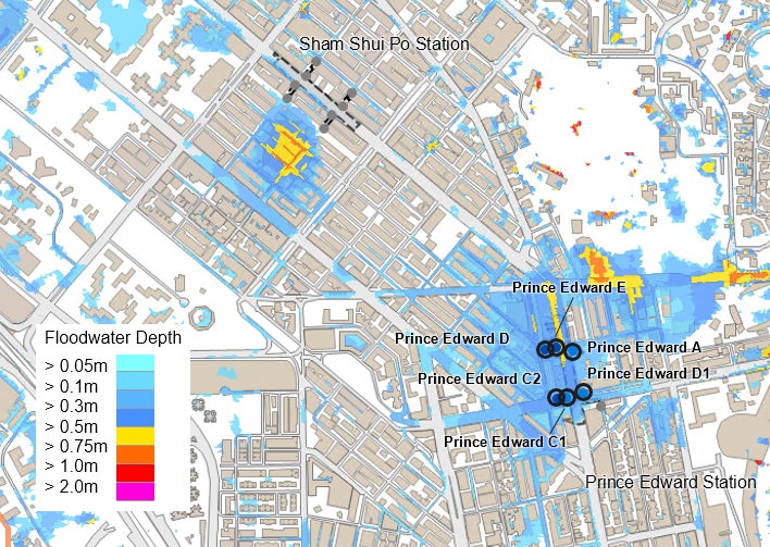
Ultimately, they were able to develop a high-level screening model of the entire Hong Kong region. This was followed by the evaluation of risk at each of the 300+ Mass Transit Railway (MTR) premises – like stations and depots - using network results lines, points, and polygons. Key stations were subsequently modeled in more detail, including the more precise definition of urban features including kerbs, walls, and buildings.
The team also used InfoWorks ICM’s thematic mapping styles to visually represent the impacts of climate change, in particular showing the extent of flooding and the potential for flooding of station entrances across a large area of Hong Kong. The model calculated the risk of flooding (2020 and 2081/21 design horizon) - while accounting for climate change. It also identified flood volumes and depths at station access points to aid in the preparation of a progressive risk adaptation and protection plan. This will enable the client to target long-term investments and ensure security of service in the face of current and future flood risks.
Tying it all together in a single, comprehensive modeling environment
Using InfoWorks ICM, Arcadis was able to provide an efficient, top-down assessment of risk for multiple spatial and detail scales, enabling a practical understanding of comparative risk and mechanisms. “InfoWorks ICM can easily and effectively integrate all elements of drainage systems and topography, including 2D boundary conditions to incorporate wave overtopping flows,” says Simon Ainley, Principal Urban Drainage Specialist at Arcadis.
They were even able to incorporate coastal and rainfall influences, all within a single modeling environment. All of this worked together to help Hong Kong MTR develop a robust and achievable long-term investment strategy – accommodating for both growth and climate change pressures.
Advice for water professionals
Visit our water blog for ideas and insights: